

We are probably Malawi’s leading eco-travel company and organize Safari, Hiking and Cycling tours for individuals, couples, families and groups around Malawi and some parts of Zambia.

Immerse yourself in sustainable tourism while enjoying some of the most picturesque landscapes and crystal-clear waters of Nkhata Bay. Butterfly Space is committed to providing bespoke accommodation while supporting various community development projects.
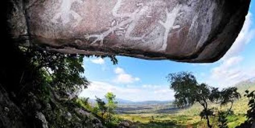
Chongoni Rock Art Area is located in the Central Region, near Dezda. There are 127 sites (126 km2) in the forested hills of the Malawi plateau with depictions of rock art and paintings of the farmer community of the Late Stone Age and the Iron Age period. This ancient record of the cultural history is fashionable even now.
The rock arts are in granite formations and consist of art depictions attributed to the hunter gatherer community of BaTwa who lived here during the stone age period, and of the farming community of Chewa who are traced to the Iron Age period. In view of this cultural importance, the area was inscribed as a UNESCO World Heritage Site in 2006 under Criteria III for the rich cultural traditions of rock art and Criteria VI for its continued link to the present society.

Dedza Mountain is a mountain in central Malawi. It is located in Dedza District, just north of the town of Dedza. Dedza Mountain's peak reaches 2198 meters elevation. Dedza Mountain Forest Reserve was established in 1926, and covers an area of 2917 ha.. Plantations of introduced pine trees cover much of the mountain, but there are remnant patches of native montane evergreen forest near the summit, and riparian forests in ravines. The native forests are home to numerous epiphytic orchids and other species.

Dzalanyama Forest Reserve, 60 km south-west of Lilongwe, is almost entirely covered with Brachystegia–Julbernardia woodland. It forms part of the Dzalanyama Range, a series of rocky hills running north-west–south-east along the border with Mozambique, which marks the watershed between Lake Malawi and the Zambezi river system. The eastern side of the reserve is relatively flat, at about 1,300 m. The hills to the west rise above 1,500 m with several peaks over 1,600 m. A few small patches (c.75 ha) of mid-altitude forest occur on the highest ridge near Kasito Rock. Dambos occur along many of the drainage lines, breaking the continuity of the woodland cover. A Pinus–Eucalyptus plantation has been established in the reserve and covers about 5% of the land area. On the Mozambique side, the woodland extends uninterrupted over a much larger area with little sign of human settlement evident.
For more information, click here.

Hikers Alliance is a established in 2019 We aim at promoting tourism through hiking and ensures that the environment is sustainably looked after.

Kuti is an ideal getaway for peace and quiet and only a 1 hour drive from Lilongwe on the way to the lake – just before Salima Town – great for families – we have no predators so it is very safe to walk, run or cycle around. We have beautiful sunsets, and lovely viewing of animals. We have outstanding birds ( over 250 different species) at Kuti. Kuti runs entirely on Solar power, we are eco-friendly, we also have an indigenous tree reforestation program.

Mufasa Eco Lodge is located in a pristine cove on the Southern shores of Lake Malawi, secluded with a private beach, but within walking distance from Monkey Bay Town and the boarding point of the Ilala Ferry.
Enjoy the spectacular view over the lake, bordered by natural forest, rock formations, an island and a wetland. It is situated at the East end of Lake Malawi National Park and part of the bordering forest reserves and marine life falls within the Park.

Welcome to Mulanje Adventures. I know we're biased but we think Mulanje is the best place - there is so much to see and do.
Mulanje Adventures is a dedicated and locally based guiding service for activities in Mulanje.

The Mulanje Massif, also known as Mount Mulanje, is a large inselberg in southern Malawi only 65 km east of Blantyre, rising sharply from the surrounding plains of Phalombe, and the tea-growing Mulanje district. It measures approximately 13x16 miles (22x26 kilometers) and has a maximum elevation of 3,002 m at its highest point, Sapitwa Peak. Some great companies can also take you there for a great time such as Mulanje Adventures.
